The Creation of the Reserve
In 1967 Hahei landowner Vaughan Harsant began discussions with the Department of Lands and Survey about protecting part of his coastal property for public use. Concerned that increasing development could eventually close off access to the coast, Vaughan proposed that land adjoining the Pickersgill Scenic Reserve be set aside as a public reserve. After several years of correspondence, inspections, and negotiation, the Cathedral Cove Recreation Reserve was finally established in 1972—ensuring that this remarkable coastline would remain open for everyone to enjoy.
The Begnnning
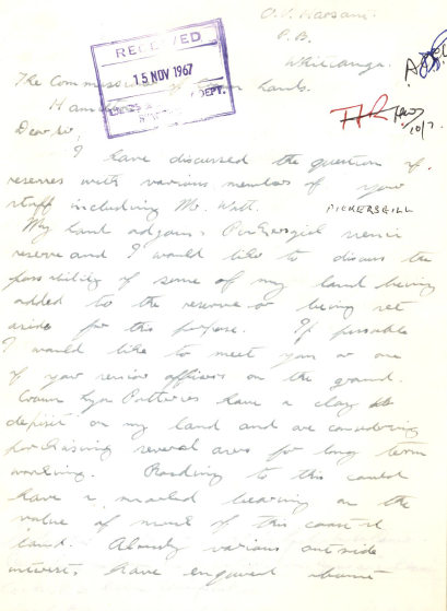
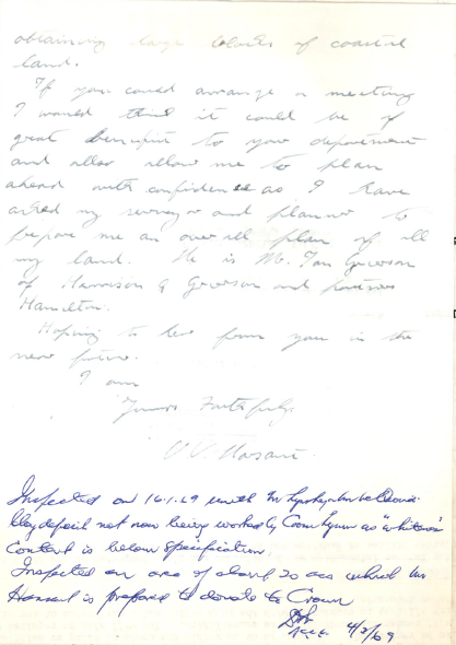
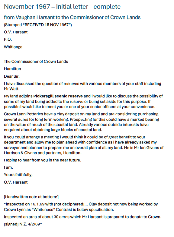
November 1967
The story of how the land at Cathedral Cove became a public reserve began in November 1967, when local landowner Vaughan Harsant wrote to the Commissioner of Crown Lands in Hamilton. His property adjoined the Pickersgill Scenic Reserve, and he suggested that part of his coastal land might be added to the reserve or set aside for public use. In his letter, he asked to meet with officials to discuss the possibility and noted that he had already begun surveying and planning the future of his land.
At the time, several factors were influencing the future of the coastline. Crown Lynn Potteries had identified a clay deposit on Vaughan’s property and were considering purchasing land for long-term extraction. Meanwhile, interest in acquiring coastal land was increasing, particularly as improved access to the Coromandel Peninsula began to attract more visitors and development. Vaughan was clearly thinking ahead: he wanted to understand the Government’s intentions so he could plan responsibly for the future of his property while ensuring that the coastline could remain accessible to the public.
Progress, however, was slow.
Click on the images above to expand
1968
Following the opening of the Kopu-Hikuai road in 1967.
In March 1968 Vaughan wrote again, expressing concern about possible developments and the lack of clarity around the future of the area. Later that year, in July, Field Officer P. G. Monrad visited Hahei to inspect the land. His report described a settlement already beginning to grow. Hahei had a general store, a large campground—one of the biggest on the peninsula—and even a small nine-hole golf course (on land now occupied by Robyn Crescent, Michelle Lane and Kotare Reserve). Monrad recommended that the Department take prompt steps to investigate acquiring land and extending the reserve.
That October, Vaughan travelled to Hamilton to meet departmental staff and discuss the proposal in person. Shortly afterwards he formally wrote again, offering land for inclusion in the reserve. Yet the process continued to move slowly.
By December 1968 Vaughan had grown concerned enough to write to the local Member of Parliament for Hauraki, Mr Kinsella, asking whether progress could be hastened. In the same letter he raised another local issue—the limited telephone service in Hahei, which at the time operated on a five-person party line through the newly established postal agency in the general store. He also pointed out that land prices were rising rapidly following the opening of the Kopu–Hikuai road, with sections at Pauanui already selling for as much as £6,300.
1969
A year of action.
Government officials soon became involved. The Minister of Lands replied that the matter was being examined, and in early 1969 the Director-General of Lands urgently requested an explanation as to why Vaughan’s offer had not yet been properly addressed. Departmental staff admitted that the delay had resulted largely from the heavy workload within the reserves administration.
Field Officer Monrad visited again in March 1969, and, accompanied by Vaughan inspected the land and noted that a clay track—associated with the Crown Lynn prospecting—provided access to parts of the area. Monrad also observed that grazing stock on the land would help prevent the reserve from reverting to scrub, maintaining its open character. During the previous Christmas period he estimated that as many as 1,500 people had visited the area, demonstrating its growing popularity. Vaughan had already received several offers to buy the coastal land but was reluctant to sell privately, as he was concerned that private ownership could result in the coastline being closed off and public access lost.
Monrad again recommended that the Crown acquire the land.
Despite this support, progress continued slowly. By May 1969 Vaughan had become frustrated with the lack of action and wrote to withdraw his offer. In that letter he again pointed out the rapidly increasing value of coastal land, noting that sections were already selling for around $6,000. He also warned that if rising costs—such as increased rates on his motor camp—forced him to close the business, he might have no option but to subdivide and sell the land.
The withdrawal of the offer finally prompted decisive attention from Wellington. The Director-General advised the Commissioner of Crown Lands that the Minister wanted the matter resolved satisfactorily. Within weeks, discussions resumed. By July 1969 Vaughan explained that his withdrawal had been intended to prompt action and that he was prepared to reconsider the proposal. On 21 July 1969, the offer of land to the Crown was renewed.
Progress gradually followed. By September 1969 the formal terms of the gift were being set out, including an agreement that the Department would take responsibility for controlling noxious weeds on the reserve. Officials even suggested that the new reserve be named in Vaughan’s honour. While the family agreed with the idea, Vaughan himself remained uncertain about the proposal.
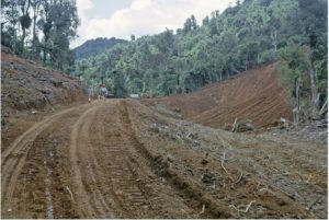
During October that year, quotes were obtained for surveying the land and for constructing a new access road—what would eventually become Grange Road. In November papers were prepared for the commissioner of Crown Lands setting out the full agreement. Once again Vaughan’s intent was made clear . Within the Terms was the followiing:
(j) The public shall at all times have access on foot to all parts of the land not in permitted crops or newly laid grass…..
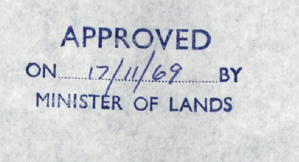
Finally on the 17th of November 1969 the proposal got the seal of approval from the Minister.
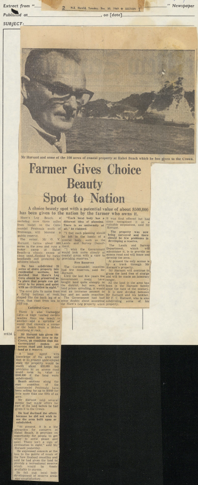
On Tuesday 30th December 1969, the New Zealand Herald carried the following article.
Click on the images above to expand
The 1970s
The Reserve takes shape
When the final transfer documents were finally prepared in 1972 (covering the transfer / merger of existing Crown Lands), the reserve was initially recorded under the name “Cathedral Cave.” The wording appeared somewhat inconsistent, as Vaughan had erected signage for “Cathedral Cove”. In May that year the Commissioner of Crown Lands noted that there was merit in the name “Cathedral Cove”, particularly as the large sign already used the word “Cave” while Vaughan himself referred to it as “Cove.” The Commissioner requested that the sign be corrected and that the official name be changed accordingly through the Gazette.
The final stage of the transfer (incorporating additional adjacent Crown Lands) was approved in June 1972. Writing to the Minister of Lands, the Director-General noted that the reserve had become “freely available to the public” following the completion of new roading (Grange Road) subsidised by the Department as a condition of the land gift.
Work continued throughout the 1970s to improve the reserve. Gorse was cleared, pine trees were felled or poisoned, and access tracks were developed. Progress was sometimes slow, reflecting the same administrative pressures that had delayed the original negotiations, and Vaughan occasionally expressed concern about the lack of a clear management plan for the area.
Throughout the process, Vaughan repeatedly made it clear that he did not want to see this stretch of coastline closed off by private development. Despite receiving offers to purchase the land, he consistently favoured a solution that would keep the coast open for everyone to enjoy.
Today, thousands of visitors walk the track each year to reach Cathedral Cove—thanks in large part to Vaughan’s decision, nearly sixty years ago, to ensure that this remarkable stretch of coast would remain publicly accessible.
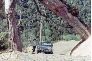
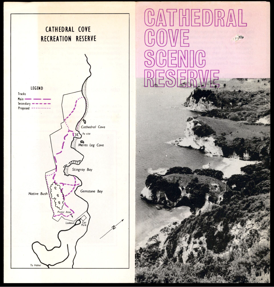
An Informational fold-out from pre-1978 when Mare's Leg collapsed in a storm
This is the initial print run which incorrectly refers to the Scenic Reserve – it should have been recreational reserve. Government finances being what they are it was only corrected when they had to print a revised version later!
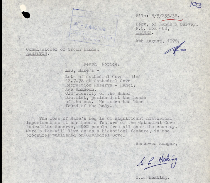
18th July 1978
The Storm that Brought Down Mare’s Leg
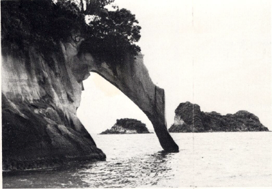
For many years one of the most distinctive landmarks on the Cathedral Cove coastline was a tall rock pillar known locally as “Mare’s Leg.” Standing just offshore from the cliffs near the cove, the narrow column of rock was a familiar sight in photographs of the area through the 1950s and 1960s.
The formation was destroyed during a severe coastal storm that struck the Coromandel Peninsula on 18 July 1978. The storm brought strong north-easterly winds, heavy seas, and unusually high tides along much of the north-east coast of the North Island. Beaches across the Coromandel experienced significant erosion, and at Hahei large amounts of sand were stripped from the beach, probably to a similar levels as after Cyclone Gabrielle in February 2023.
During the height of the storm the already-weakened rock column collapsed and the Mare’s Leg formation was lost. Contemporary records held in the archives show that the local Reserves Ranger C.L. Hosking put on a brave face when reporting the loss to the Commissioner of Crown Crown Lands
Click to enlarge
Its been truly fascinating to research the history of this reserve. If you have any additional material you are willing to share please email us or add it in a comment below. I’d love to find out where the “Pickersgill” Scenic Reserve was, and if anyone has a first day cover from the Hahei Post Office which would be another good one to add in 🙂